Kimberley Western Australia Map: Where to Find This Rugged Beauty
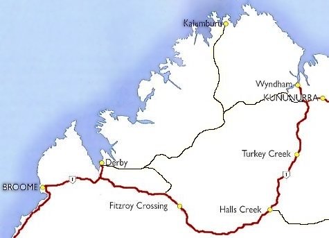
Kimberley Western Australia is a region renowned for its stunning landscapes, rich Indigenous culture, and diverse wildlife. To truly appreciate its rugged beauty, a well-crafted map is an indispensable tool. This article delves into the significance of having a Kimberley Western Australia map, offers insights into its exceptional geographical features, and guides you on where to find this essential resource.
Understanding the Kimberley Region
The Kimberley is one of Australia’s last true wildernesses. Located in the northern part of Western Australia, this expansive area spans over 420,000 square kilometers, roughly the size of California. Characterized by its dramatic cliffs, secluded beaches, and spectacular gorges, the Kimberley is a haven for adventurers and nature enthusiasts alike.
This region is famed for its diverse ecosystems, from the arid deserts of the Great Sandy Desert to the lush rainforests in the north. Each of these ecosystems is rich in flora and fauna, including unique species that are endemic to the area. Understanding the geographical layout is essential for anyone looking to explore its hidden gems, such as the Bungle Bungles, Horizontal Falls, and Lake Argyle.
Why a Map is Essential
A Kimberley Western Australia map serves as a critical companion for anyone traversing this magnificent landscape. Due to its vast and often rugged terrain, navigating the region without a reliable map can be daunting. A comprehensive map provides a visual representation of the region’s topography, highlighting key features such as rivers, mountains, and parks.
Moreover, a detailed map can help travelers locate Indigenous heritage sites, which are integral to the cultural fabric of the Kimberley. Understanding the historical significance of these sites fosters respect and appreciation for the Indigenous peoples who have lived in this region for thousands of years.
Types of Maps Available
When looking for a map of the Kimberley, one may come across various options crafted for different purposes. Topographic maps are ideal for those planning to hike or engage in outdoor activities, as they illustrate the elevation and terrain of the landscape. These maps offer an abundance of detail that can be crucial for navigating through rugged trails and escarpments.
For a more focused exploration, road maps and tourist maps are also widely available. These versions often highlight significant landmarks, accommodations, and attractions, making them suitable for road trips and leisurely exploration. Regional and digital maps are increasingly popular, providing real-time updates and detailing available services, which can be incredibly advantageous.
Where to Find the Perfect Map
For those who prefer convenience, many websites offer downloadable maps and digital applications for smartphones. Utilizing technology allows for greater flexibility, especially in remote regions where traditional maps may fall short.
Exploring the Kimberley
Once equipped with a detailed map, adventurers can embark on a journey through the Kimberley’s awe-inspiring landscapes. Expect to traverse diverse terrains, encounter magnificent waterfalls, and experience vibrant marine life along the stunning coastline.
Wildlife enthusiasts will appreciate the chance to witness native animals in their natural habitats, whether it’s the elusive saltwater crocodiles in the rivers or the plethora of bird species migrating through the area. Each bend in the trail provides an opportunity to capture the untouched beauty of nature.
Conclusion
The Kimberley region of Western Australia, with its breathtaking landscapes and rich cultural heritage, beckons intrepid travelers. A well-executed map not only enhances your experience but also ensures a safe journey through this rugged paradise. By gaining a deeper understanding of the terrain, obtaining the right type of map, and immersing oneself in the awe of the region, one can truly appreciate the Kimberley’s extraordinary offerings. Prepare to venture into one of Australia’s last frontiers, armed with the valuable knowledge that a map brings.
You May Also Like
Best Fish to Catch in Australia: A Guide for Anglers
Australia boasts an extraordinary diversity of fish species, making it …
Emily Bay Norfolk Island: A Hidden Gem in the Pacific
Emily Bay, a picturesque enclave nestled on the sun-kissed shores of …
Holidays on August 23: Global Festivities & Observances
August 23 is a date that carries a bouquet of cultural significance …


