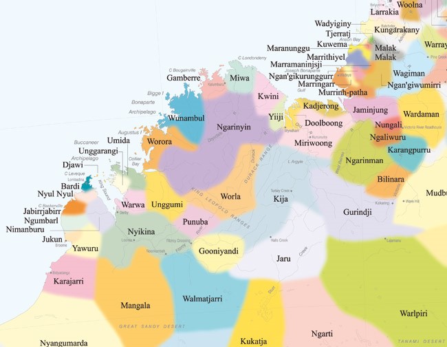
Kimberley Region WA Map: How to Explore This Untamed Landscape
Exploring the Kimberley Region of Western Australia is akin to embarking on a journey through time, where ancient landscapes meet vibrant cultures. The Kimberley Map serves as a vital navigational tool that unlocks the secrets of this untamed wilderness. With its sprawling gorges, rugged coastline, and pristine waterfalls, the Kimberley beckons to adventurers and wanderers alike. This article delves into the various facets of the Kimberley Region, revealing how to effectively explore this extraordinary landscape.
Geographical Overview of the Kimberley Region
The Kimberley Region, one of the most sparsely populated areas in Australia, encompasses around 420,000 square kilometers of breathtaking wilderness. This remote corner of Western Australia is bordered by the Indian Ocean to the west, the Timor Sea to the north, and the Great Sandy Desert to the south. The distinct geography consists of dramatic cliffs, expansive wetlands, and lush rainforests. The landscape is punctuated by iconic natural wonders such as the Bungle Bungles, Horizontal Falls, and the mesmerizing Mitchell Falls.
Understanding the Kimberley Map is essential for navigating this diverse terrain. The map not only highlights key attractions but also provides vital information regarding access routes, topographic features, and even local wildlife habitats. Whether you’re planning a day trip or an extensive road trip, possessing a detailed map can enhance your exploration experience immensely.
Top Natural Wonders to Discover
One cannot traverse the Kimberley without acknowledging its prodigious natural wonders. Each attraction offers unique experiences that cater to different interests.
The Bungle Bungles, a UNESCO World Heritage Site, are famous for their striped orange and grey sandstone domes. Visitors can hike through Cathedral Gorge or embark on a scenic helicopter flight for a bird’s-eye view of these geological marvels. The Bungles also house ancient Indigenous rock art that provides insights into the rich cultural history of the region.
Mitchell Falls is another gem within the Kimberley, where cascading water plummets into striking pools below. Accessible only by a rugged trek or helicopter ride, the experience is thoroughly rewarding. The surrounding area teems with wildlife, offering glimpses of natural flora and fauna native to this unique ecosystem.
Waterfalls such as Emma Gorge and King George Falls present stunning vistas and tranquil swimming spots, perfect for a refreshing dip after a day of exploration. Additionally, the Horizontal Falls, where tides create a mesmerizing spectacle of water rushing through narrow gorges, is an experience that often leaves visitors in awe.
Facets of Indigenous Culture
The Kimberley Region is steeped in Indigenous culture, with one of the longest continuous histories of human habitation on the planet. Engaging with local Indigenous communities can offer invaluable perspectives on their traditions, storytelling, and art. The map can help pinpoint significant cultural sites where guided tours provide deeper understanding of their connection to the land.
Art sites like the renowned Aboriginal rock art at Wandjina and Bradshaw offer striking visual narratives that capture the spiritual connection of Indigenous Australians to this land. Engaging in cultural tours allows visitors to witness traditional dances, learn about bush tucker, and appreciate the stories etched into the earth through art.
The Importance of Responsible Exploration
Venturing into the Kimberley is a profound experience that comes with great responsibility. Respect for the land, local wildlife, and cultural heritage is paramount. Visitors are encouraged to follow established guidelines, stick to marked paths, and safeguard the pristine environment. Utilizing the Kimberley Map can assist in making informed decisions about camping sites and areas that require special care.
Moreover, seeking out eco-friendly tours and accommodations can support sustainable practices that protect this fragile landscape. Engaging with Indigenous-led initiatives can further enrich your understanding and appreciation of the environment while providing essential economic support to local communities.
Conclusion
The Kimberley region offers both breathtaking scenery and profound cultural experiences, making it one of Australia’s most captivating destinations. With the aid of the Kimberley Map, adventurers can navigate its rugged beauty, uncovering the treasures that lie within its expansive landscapes. From awe-inspiring natural wonders to the rich tapestry of Indigenous culture, exploring the Kimberley is not just a journey through wilderness—it’s an expedition into the heart of a resilient land brimming with stories waiting to be discovered.
You May Also Like
Best Fish to Catch in Australia: A Guide for Anglers
Australia boasts an extraordinary diversity of fish species, making it …
Emily Bay Norfolk Island: A Hidden Gem in the Pacific
Emily Bay, a picturesque enclave nestled on the sun-kissed shores of …
Holidays on August 23: Global Festivities & Observances
August 23 is a date that carries a bouquet of cultural significance …


