Kimberley Region Map: Exploring Western Australia's Wilderness
Exploring the Kimberley Region: A Quintessential Wilderness Experience
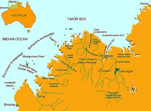
The Kimberley region in Western Australia embodies a mesmerizing tapestry of natural wonders, characterized by its rugged landscapes, scintillating coastlines, and a rich tapestry of flora and fauna. From the Dawson River to the magnificent coastline along the Indian Ocean, the area is a treasure trove for travelers seeking an adventurous escape into nature. One cannot fully appreciate the intricacies of this vast region without examining the Kimberley Region Map, which serves as an essential tool for navigating its breathtaking topography and diverse ecosystems.
Understanding the Kimberly Region Map: Navigational Insights
The Kimberley Region Map is more than just a visual representation of the land; it serves as a pathway to discover one of Australia’s last frontiers. The map outlines key geographical features, including the awe-inspiring Bungle Bungles, the expansive Gibb River Road, and the dramatic cliffs of the Horizontal Falls. These elements are not only points of interest but also markers of the unique experiences that await adventurous souls.
At first glance, one may see merely a collection of natural formations and sites. However, a deeper inspection of the map reveals vital insights into the region’s rich geological history. The intricate patterns carved by millennia of erosion have produced breathtaking landscapes, with ancient sandstone formations standing as sentinel reminders of a time long past. Understanding these formations enriches the visitor’s experience and allows for a more profound connection to the land.
Moreover, the map delineates protected areas such as the Wilderness Parks and Marine Reserves, emphasizing the importance of conservation in maintaining the region’s natural beauty. The interconnected systems of rivers and estuaries are critical not only for supporting biodiversity but also for cultural practices of the Indigenous peoples who have inhabited this area for tens of thousands of years. A respectful approach to exploration includes acknowledging and understanding these cultures, adding another dimension to the journey.
The Lure of the Breathtaking Landscapes
One of the most striking features illustrated on the Kimberley Region Map is its dramatic landscapes. The Bungle Bungles, often regarded as one of Australia’s most iconic sites, captivates with its beehive-shaped towers characterized by distinct orange and black stripes. Visitors are drawn to the area not only for its photogenic vistas but also for the opportunity to hike among ancient rock formations. The Purnululu National Park, home to the Bungle Bungles, offers trails that lead through stunning gorges and around hidden waterholes, showcasing nature’s artful handiwork. Exploration here encourages mindfulness and a sense of interconnectedness with the Earth.
Similarly, the Kimberley’s coastline, teeming with life, beckons adventurers seeking the thrill of exploring hidden coves and pristine beaches. The Horizontal Falls, hailed as one of the most unique natural phenomena, provides a heart-pounding experience as tides rush through narrow gorges. Engaging with such dynamic environments highlights the importance of understanding tidal forces and their effects on marine ecosystems, offering a captivating experience rooted in science and nature.
Cultural Connections: Respecting Indigenous Heritage
In addition to its striking geography, the Kimberley region is rich in Indigenous culture. Aboriginal peoples, such as the Yawuru and Gooniyandi, have lived in harmony with this land for countless generations, profoundly influencing its history and ecology. The Kimberley Region Map often features significant cultural sites and rock art, reminders of the deep-rooted spirituality and connection these communities have with the land.
Engaging with Indigenous tour guides can offer invaluable insights into traditional practices, stories, and worldviews—knowledge that transforms an ordinary journey into an extraordinary cultural immersion. It is imperative that visitors approach these experiences with respect and a willingness to learn, thereby supporting both cultural preservation and appropriate tourism practices.
Conclusion: Embracing the Spirit of Exploration
The Kimberley Region Map invites adventurers to engage with some of Australia’s most exquisite landscapes and rich cultural histories. By examining this geographical tool, travelers gain not only navigational acuity but also an appreciation for the multifaceted narratives of this wilderness. Whether trekking through the ancient paths of the Bungle Bungles, witnessing the life vividly flourishing along the coasts, or honoring the stories of Indigenous peoples, each step taken within this enigmatic territory reveals the layers of beauty and significance that define the Kimberley region.
You May Also Like
Best Fish to Catch in Australia: A Guide for Anglers
Australia boasts an extraordinary diversity of fish species, making it …
Emily Bay Norfolk Island: A Hidden Gem in the Pacific
Emily Bay, a picturesque enclave nestled on the sun-kissed shores of …
Holidays on August 23: Global Festivities & Observances
August 23 is a date that carries a bouquet of cultural significance …


